Water Shortage? Torrential Rain? The Unexpected Things to Happen When the Rainy Season Ends Early
June heat could return once again
The unusually early end of the rainy season, followed by a series of extremely hot days and then heavy rain brought by Typhoon No. 4, has led to unstable weather.
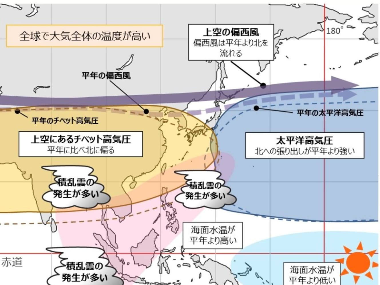
“This year, the Pacific High is expected to strengthen to the north of normal, and the Tibetan High, which is higher than the Pacific High, is also expected to strengthen to the north of normal. These two high-pressure systems will bring warmer temperatures to western and eastern Japan, as well as northern Japan.”
Says Sayaka Ikeda, a weather forecaster.
This year’s record-breaking heat, with temperatures exceeding 40°C (104°F) in June and Tokyo experiencing the hottest nine consecutive hot days in its history, may return.
A typhoon with an undefined path. There is also a possibility of frequent guerrilla downpours.
Moreover, due to the La Niña phenomenon, cumulonimbus clouds are likely to form in the southern ocean of the Japanese archipelago, which is closer to Japan than usual.
Like Typhoon No. 4, it may be more likely to form near the Philippines. If that is the case, the typhoon will approach the Okinawa area soon after its formation and will have an impact on the area.
Moreover, the typhoon’s path is difficult to determine.
Typhoons move along the edge of the Pacific High. If the Pacific High extends to western Japan, it will block the typhoon. But this year, it is likely to extend further north than usual. Therefore, it may not be able to ride out the Pacific High’s winds and may take a wandering and complicated path.
Typhoon No. 4 was slow, but there is a possibility that it will remain near Japan indefinitely, just as it did then.
“Due in part to global warming, the trend toward higher temperatures is continuing, and the amount of rainfall at any one time is increasing. The frequency of localized, short-duration heavy rains in summer is likely to increase, and the intensity is expected to increase as well.”
What a surprise, he said, guerrilla downpours are likely to occur more than once.
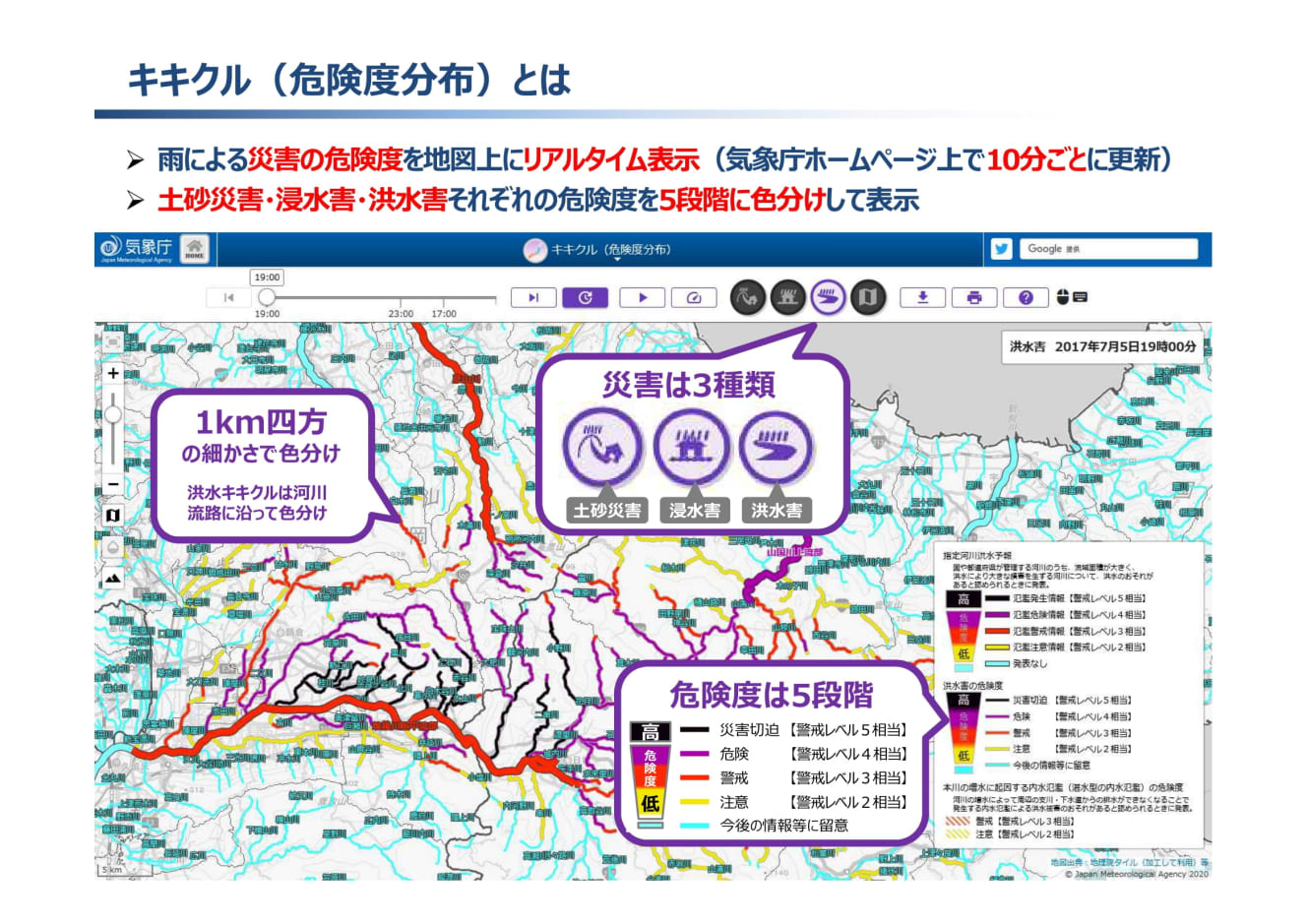
When you hear words like “unstable atmospheric conditions” in the weather forecast, there is a possibility of a sudden change in the weather. When the rain actually intensifies, it is a good idea to check the “Kikkilu” to see how dangerous it currently is and use it as a reference for evacuation.
La Niña Phenomenon x Double Punch of Pacific High and Tibetan High. Great Potential for Record Breaking
But it shouldn’t be all bad. The early end of the rainy season had caused concerns about water shortages, but Typhoon No. 4 may have resolved these concerns in many places.
“The Hayamaura Dam in Kochi Prefecture received more than 100 mm of rainfall as a result of Typhoon No. 4, and the restrictions on water intake were lifted. However, the Asahikawa River system in Okayama Prefecture is still under primary water withdrawal restrictions due to the low rainfall in the basin. The flow of water caused by the typhoon is temporary, so if it doesn’t rain for a while, the water withdrawal restrictions will start soon.”
2010 and 2018 were also hot. In any case, “hot” was chosen as this year’s Kanji character for 2010, and “disaster-grade heat” was even selected as one of the top ten new words and phrases for 2018.
In 2010, which had the highest average summer (June-August) temperature in the past 113 years, the La Niña phenomenon was thought to have contributed to the heat, as was the case this year, and in 2018, the temperature increased as the Pacific High and Tibetan High overhung near Japan. On July 23, a maximum temperature of 41.1°C was recorded in Kumagaya, Saitama Prefecture, and more than 40°C was recorded in Hokuriku for the first time in observation history.
This year’s double whammy of La Niña and the Pacific and Tibetan highs could further break 2018’s record.
Of concern is the impact on crops: in 2010, the heat wave delayed the growth of vegetables, and according to a retail price survey by the Ministry of Agriculture, Forestry and Fisheries, tomatoes and green onions were more than 40% higher than normal, eggplant was about 30% higher, and lettuce and potatoes were about 20% higher than normal. In addition, scallops in Mutsu Bay, Aomori Prefecture, and oysters in Atsukishi, Hokkaido, died in large numbers. At Toyama City Family Park, five of 13 Humboldt penguins in captivity died of dehydration.
Pig farmers are already complaining this year that their pigs have lost their appetite due to the heat and are not gaining weight.
Electricity is also a concern.
Records were broken by various power companies, including Tokyo Electric Power Company’s maximum hourly power consumption of 59.99 million kilowatts on July 23, 2010.
Even if this is not the case, what will happen if it gets any hotter now that prices are rising and people are being told to save electricity due to power shortages? All we can do is pray that we can make it through the summer safely.
Sayaka Ikeda is from Hiroshima Prefecture and became a certified meteorologist in 2015. She has appeared on “Asaichi” (NHK Sogo), “Jane Sue: Life is Dance,” “Tamamusubi,” “Ogigami Chiki Session,” “5 O’clock News, Weather Report,” “Takayuki Hasumi: Matomete! Saturday” and “Saturday Wide Radio TOKYO Nights’ Chaki-Chaki-Daihoso” (TBS Radio Tuesdays and Saturdays), providing weather information.

Interview and text by: Izumi Nakagawa