Total precipitation in Kanto area may exceed 500mm! What to do now!
Typhoon No. 14] Latest weather alert by Sayaka Ikeda
Typhoon No. 14 will have a major impact on commuting to work and school on the last day of the holiday weekend (Monday) and the end of the holiday weekend (Tuesday) in the Kanto region!
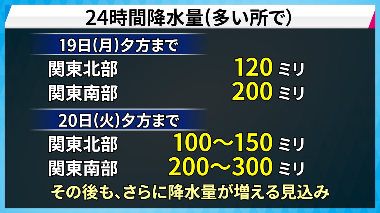
The current forecast for rainfall is 200mm in many places in the southern Kanto region during the 24-hour period ending on the evening of Monday the 19th. The rainfall is expected to intensify as Typhoon No. 14 approaches, and there is a risk of 300 mm of rain in the southern Kanto region in the 24-hour period ending on the evening of Tuesday, March 20.
Typhoon No. 14 is large and the rain is expected to intensify before its approach, prolonging its impact, and there is a risk of significantly more rainfall from the beginning of the downpour.
In addition, atmospheric conditions were unstable before the typhoon approached, and in some places in the Kanto region, rainfall exceeded expectations, causing river levels to rise.
In a normal year, Tokyo receives 224.9 millimeters of rainfall in the month of September, and this time there is a risk of more than that amount falling at once in the southern Kanto region. Be on the lookout for landslides, flooding of low-lying areas, and overflowing rivers.
Large and extremely powerful Typhoon No. 14, one of the strongest typhoons ever, moving toward Kyushu.
Typhoon No. 14, a large and extremely powerful typhoon, passed near Yakushima Island at around 13:30 on September 18 with a central pressure of 930 hPa.
At a press conference held by the Japan Meteorological Agency before noon on the 17th, the typhoon was forecast to be stronger than Typhoon No. 21, which caused a collision with a tanker in Osaka Bay in 2018, and said it would be difficult to find a similar typhoon in recent years.
Also, on the night of the 17th, a “special typhoon-related warning” was issued for Kagoshima Prefecture for the first time in Kyushu.
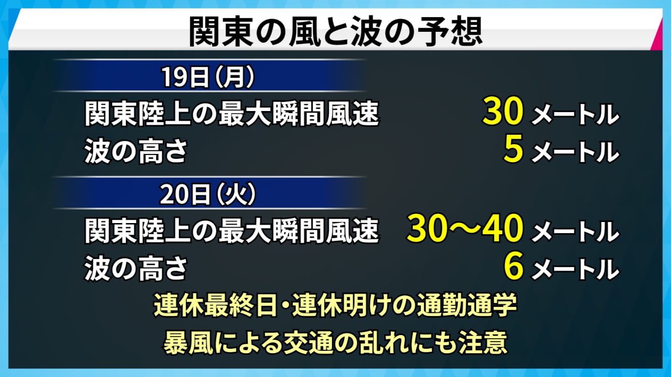
By the time it approaches the Kanto area, it will be less powerful than it is now, but the latest forecast is for maximum instantaneous winds of 30 to 40 meters over the Kanto land area on Tuesday, March 20. The typhoon is expected to approach the Kanto area with a storm zone.
If the center of the typhoon moves toward the center of the forecast circle, the Kanto area will be in the “danger semicircle” on the right side of the typhoon’s direction of movement, where winds are likely to intensify. In addition to heavy rainfall, storms and accompanying high waves are also likely to be a concern.
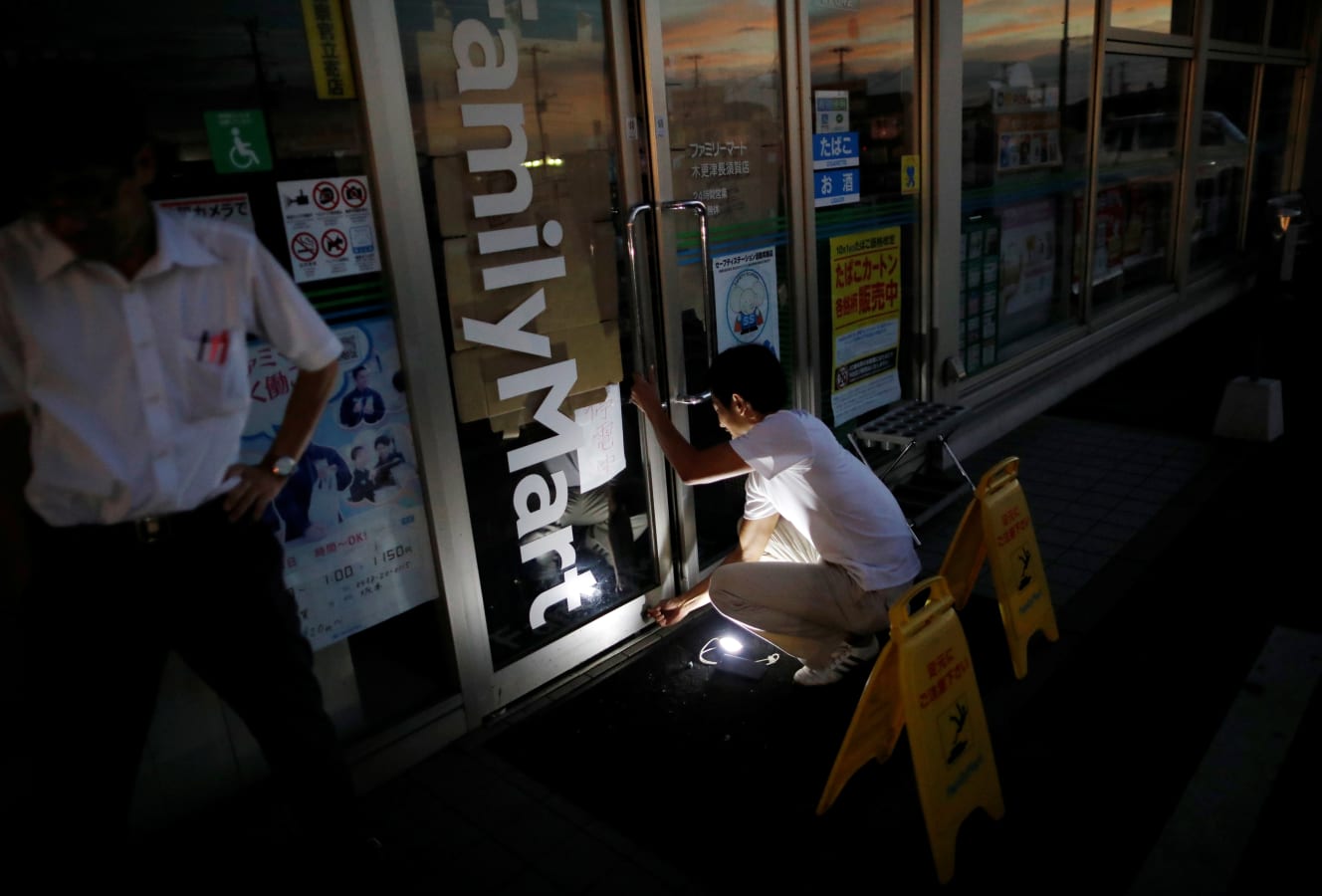
Commuting in the Kanto region will be affected on the last day of the holiday weekend and after the holiday! Be careful of power outages!
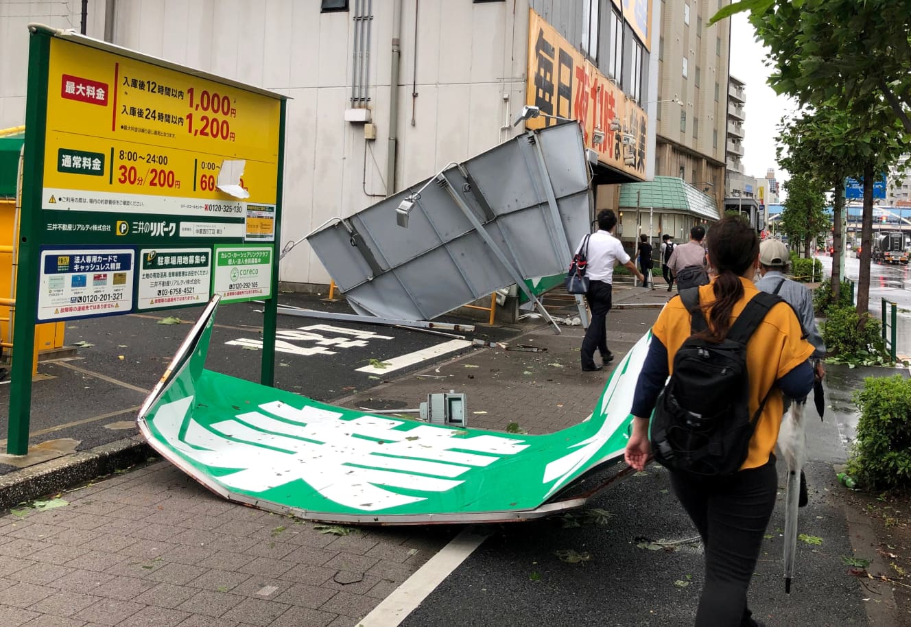
The typhoon No. 14 has been traversing the Japanese archipelago during the three-day weekend, affecting a wide area, including the planned suspension of Shinkansen services. In the Kanto area, rain and wind are expected to peak on the final day of the holiday, Respect-for-Senior-Citizens Day, and on Tuesday, the day after the holiday. Especially during commuting hours on Tuesday, winds are expected to be extremely strong, with maximum instantaneous wind speeds of 30-40 m/s, “so strong that you will have to hold on to something to stand up.
In addition, many schools will be closed when storm warnings are issued, so it is necessary to check the latest weather and traffic information frequently.

Example of “300 mm rainfall in 3 days” in Kanto… 2021, Hiratsuka, Kanagawa prefecture, Japan, to be heavily flooded.
In July 2021, a rainy season front caused 343.5 mm of rainfall in Hiratsuka, Kanagawa Prefecture, over three days: 68.5 mm on July 1, 105.5 mm on July 2, and 169.5 mm on July 3. The rain front caused 343.5 mm of heavy rain in Hiratsuka City, Kanagawa Prefecture on July 1, 105.5 mm on July 2, and 169.5 mm on July 3. The banks of the Kaname River partially collapsed. The banks of the Kaname River partially collapsed, causing massive flooding, and an “emergency safety precaution” was issued for some 89,000 households and 200,000 people living in the river’s vicinity.
While flooding of the river is a concern during heavy rainfall, attention should also be paid to flooding of roads when the sewage pipes exceed their capacity to handle the flooding. Rainwater in Tokyo is drained through sewage pipes, but the capacity is limited to 50millimetersperhour. If more rain falls than that, the drainage capacitywill not be able to keep up. This may cause the sewage system to overflow, turning the street into a river and flooding semi-underground parking lots.
Rainfall of 30 mm or more in an hour can cause braking problems when driving a car at high speeds, and rainfall exceeding 50 mm increases the risk of a landslide disaster. Flooding of basements and water spewing out of manholes are also possible, so caution is required.
What is a storm with a maximum instantaneous wind speed of 30 to 40 m/s?
The typhoon is expected to cause winds of up to 30-40 m/s in the Kanto region. Express buses and street buses are suspended at wind speeds of 30 m/s.
Typhoon No. 15 in 2019 recorded a maximum instantaneous wind speed of 57.5 m/s in Chiba Prefecture. A power transmission tower collapsed, causing a massive power outage to approximately 930,000 homes. Analysis has shown that power outages occur when the maximum instantaneous wind speed reaches 40 m/s, so we need to be careful about power outages as well.
Check hazard maps regularly. If a warning is issued, prepare early.
It is important to check hazard maps to understand what hazards are present where you live, where you work, and where your children’s school is located. Hazard maps are updated from time to time, so be sure to check them regularly. If there seems to be a risk of disaster, check evacuation sites and routes.
Check the following before the rain gets worse.
- □Check for clogged drains and rain gutters.
- □Prepare food and water for 2-3 days
- □Batteries and batteries
- □Fill up the gas tank of your car.
- □Check if the batteries in your flashlight are dead
- □Radio (Prepare multiple ways to get information so as not to use your phone’s charge as much as possible)
- □Cash (electronic money and credit cards will not work in the event of a power outage)
On the day of the disaster, consider evacuation if the alert level reaches 3.
The Japan Meteorological Agency (JMA) publishes a “kikikuru,” a map showing five color-coded levels of increased risk of flooding and landslides in small and medium-sized rivers due to heavy rainfall.
Based on information from the JMA, evacuation orders are issued by municipalities. When “Alert Level 3” is issued, the elderly, people with disabilities, infants, and other people who need time to evacuate should evacuate together with their supporters.
Evacuation does not mean running outside. If you are in danger of flooding, decide on a safe place, such as the second floor or higher of your house, and move immediately if you are in danger. It is important to take actions to protect your life.
Check both “Kikikuru” and information from the local municipalities, and consider what action to take.
Be careful during a torrential downpour.
- Stay away from rivers, the sea, cliffs, and underpasses.
- Avoid wearing boots when walking out (water may get inside your boots, making it difficult to walk).
- When walking out, take an umbrella or walking stick with you (manhole covers may float and fall off. (Manhole covers may float and fall off, so use an umbrella or walking stick to find your way around.)
If you evacuate to a shelter, the timing of your return is also important. Even after the peak has passed , areas where the ground has loosened may collapse. Those living near cliffs, for example, are asked to check local government evacuation information from time to time.
Sayaka Ikeda is from Hiroshima Prefecture and became a certified meteorologist in 2015. She has appeared on “Asaichi” (NHK Sogo), “Jane Sue: Life is Dance,” “Tamamusubi,” “Ogigami Chiki Session,” “5 O’clock News, Weather Report,” “Takayuki Hasumi: Matomete! Saturday” and “Saturday Wide Radio TOKYO Nights’ Chaki-Chaki-Daihoso” (TBS Radio Tuesdays and Saturdays), providing weather information.

Reporting and writing: Izumi Nakagawa